The journey here is just the tip of the iceberg.
-
Join the Anchor Inn Team in 2024
The Anchor Inn Hotel has jobs available for 2024, and […]
January 3, 2024 -
A different kind of year…
Who could have predicted that Twillingate, this picturesque island of […]
June 15, 2020 -
Iceberg Lingo
The waters off the coast of Newfoundland (Iceberg Alley) are […]
May 21, 2019
News
Getting Here
Twillingate’s charm is that it is off the beaten path. No smog, lineups, rush, stress, or traffic.
Newfoundland is the most easterly destination on the North American continent and has its own time zone (GMT – 3h30) a half hour ahead of Atlantic Standard Time (AST).
Getting Here By Air
| Airport | Drive Time To Twillingate |
|---|---|
| Gander International Airport (YQX) | 90 minutes |
| St. John’s International Airport (YYT) | 5.5 hours |
| Deer Lake International Airport (YDF) | 4.5 hours |
The closest airport is Gander International Airport, but most international flights fly into St. John’s International Airport (YYT) or also Deer Lake International Airport. From the airport, a rental vehicle is a good option.
Getting Here By Ferry
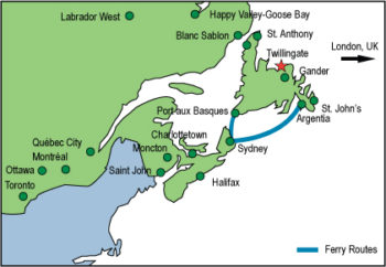
Click here for printable Map
Ferry Route |
Ferry Time |
Drive Time to Twillingate |
|---|---|---|
| North Sydney NS to Argentia | 16 hours | 4.5 hours |
| North Sydney NS to Port aux Basques | 7 hours | 7 hours |
Getting Here By Road
- From the TCH1 travelling east turn onto Route 340 to Lewisporte/Twillingate (Road to the Isles)
- On the TCH 1 travelling west to Gander, turn onto Route 330, then Routes 331 and 340 to Twillingate.(Road to the Isles)
- Lewisporte to Twillingate: 85km
- Gander to Twillingate: 90kmDistance Calculator
When driving to Twillingate you will pass through many other small fishing communities such as Boyd’s Cove, Summerford, Virgin Arm and Newville.
When on Twillingate island, there are several very small fishing communities that you will pass through before reaching the main town.
You will pass by Purcell’s Harbour and Little Harbour.
The town of Twillingate is about 5km from the Twillingate-New World Island causeway.
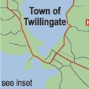
Click for printable Twillingate Map
Getting to the Hodge Premises Inn
GPS: 49.6569, -54.7748
Turn left at the T-intersection as you get into Twillingate. You are now on Main Street, which is also a continuation of Route 340. After 4.5 km, veer right onto Path End, and you’ll see the Hodge Premises Inn on your right-hand side by the ocean.
Getting to the Anchor Inn Hotel & Suites
GPS: 49.6569, -54.7748
Turn left at the T-intersection as you get into Twillingate. You are now on Main Street, which is also a continuation of Route 340. After 4.5 km, you’ll see the Anchor Inn Hotel on your right.
Getting to the Alphabet Fleet Inn
GPS: 49.646, -54.7581
As you drive into Twillingate on Route 340 (also called Toulinquet Street), you’ll see the Alphabet Fleet Inn, a green building with a large parking area, on your left (just past the Ultramar gas station and before the Independent Grocery Store)